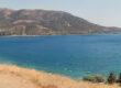
Erateini bay, from E
Ancient and Classical Era
The coastal plain around Erateini has been hospitable to people since classical times. Nearby ancient sites and references point to small coastal towns and harbors that served as nodes in the local maritime network of Phocis and the western shore of the Gulf. These communities were seldom great poleis, but they mattered for trade, fishing and the movement of people between the Gulf and the mountainous interior. The rhythms of olive and grain growth, and the seasonal round of fishing and coastal navigation, set the economic and social pattern that endured for centuries.
Roman Period
When the Romans extended their control across Greece, this stretch of the Corinthian coast became part of a broader network that linked the interior to the sea. Roman roads and administrative practices altered old routes, and small harbors along the gulf would have continued to serve local needs: moving agricultural produce, supplying coastal shipping, and hosting travelers. The overlay of Roman governance typically brought more formalized landholding and taxes, but life in small coastal towns remained rooted in maritime livelihoods.
Byzantine and Medieval Times
With the fall of the western empire, the Byzantine era reshaped the region’s identity. The seafront settlements became strategic and often precarious: the coast was a corridor for trade and for invasion, and coastal communities adapted by tightening networks of mutual aid, ecclesiastical ties, and local lordship structures. During medieval centuries — after the Fourth Crusade and the fragmentation of Byzantine authority — the Gulf’s villages alternately fell under local Greek leaders, Frankish knights, and later Ottoman rule. Many small settlements experienced cycles of abandonment and rebirth, depending on piracy, taxation, and the shifting fortunes of landowners.
Ottoman Period to 19th Century
Under Ottoman administration, coastal villages like the future Erateini were modest economic centers: sites of small-scale fishing, olive cultivation, and servicing travelers. Local inns and kiosks often marked important coastal stopping points. Oral tradition and later local records suggest that the place we now call Erateini was known in earlier centuries as a stopping point or ‘khan’ — a place where travelers and coastal traders could find accommodation and supplies. As the 19th century unfolded and the map of modern Greece took shape, the settlement grew in local importance and in population, and by royal decree in the late 19th century it acquired the toponym Erateini, a name that resonated with classical echoes and with the rising desire to anchor modern communities in a Greek past.
Modern Era — 20th Century to Today
The 20th century brought infrastructural change: schools were founded, electrification reached the village in the 1930s, and later decades added the kinds of services that turned a coastal town into a municipal center in its area. Erateini’s harbor and beach helped shape a modest tourism economy: fishermen, small-scale farmers and newcomers all shared a coastline that was increasingly valued for recreation as well as subsistence. The village sustained damage in the 20th century from earthquakes that shape much of Greece’s modern history; yet it adapted, rebuilt and continued to grow as a local hub.
Today Erateini is both a lived community and a gateway: to the sea, to mountain trails, and to the long historical landscape of Phocis. A visitor who strolls the seafront, tucks into a taverna for grilled fish and listens to local talk will hear fragments of the town’s layered past — a coastal road that once linked Roman merchants, a Byzantine parish that shaped local rhythms, an Ottoman-era roadside inn, and a modern Greek village that welcomes the slow seasons as patiently as it hosted past travelers.