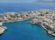
Ierapetra castle and harbour
Set along the southernmost urban shoreline of Europe, Ierapetra faces the vast openness of the Libyan Sea with a confidence shaped by millennia. Unlike the busier ports of northern Crete, this town retains a sense of measured authenticity, where agriculture, seafaring and history coexist without theatricality. For the navigator rounding Cape Sideros or descending from the Gulf of Mirabello, the approach to Ierapetra offers both shelter and narrative depth — a harbour that has witnessed Minoan mariners, Roman merchants, Venetian soldiers and Ottoman governors.
From Minoan Hinterland to Powerful Hierapytna
The wider region of Ierapetra was inhabited as early as the Minoan Bronze Age (c. 3000–1100 BC). Archaeological discoveries at nearby Vasiliki and Gournia reveal organised settlements engaged in maritime trade and agriculture. Though the ancient harbour lies beneath modern layers, the continuity of habitation suggests that this stretch of coast was never marginal; it was a gateway between Crete and the southern Mediterranean.
In antiquity the city was known as Hierapytna, one of the most assertive city-states of eastern Crete. During the 3rd and 2nd centuries BC, Hierapytna expanded territorially, often clashing with neighbouring Praisos and Itanos. Its strategic position allowed control of inland routes and maritime passages, making it both commercially prosperous and militarily ambitious. Even today, inscriptions and scattered remains speak of a confident Hellenistic polis conscious of its influence.
When Rome conquered Crete in 67 BC, Hierapytna resisted but was ultimately incorporated into the Roman province of Creta et Cyrenaica. Under Roman rule, the city flourished anew. Villas, baths and public buildings were constructed, and agricultural production intensified. The Roman phase marked a period of urban refinement and economic stability, fragments of which still emerge in rescue excavations and museum collections.
Byzantine Faith and Venetian Fortification
With the division of the Roman Empire, Ierapetra entered the Byzantine era (4th–13th centuries AD). Christianity spread rapidly, and the town became an episcopal seat. Coastal settlements, however, suffered during the Arab occupation of Crete (824–961 AD), when piracy and insecurity disrupted maritime life across the island. Following the Byzantine reconquest in 961 AD, fortifications were reinforced and ecclesiastical structures restored, signalling a return to relative stability.
A decisive transformation occurred after 1204 AD, when Crete passed into Venetian control. Venice recognised the importance of Ierapetra as a southern outpost guarding sea routes towards North Africa and the Levant. The most enduring monument of this period is the Kales Fortress, constructed in the 13th century AD at the edge of the harbour. Compact yet commanding, its thick walls and sea-facing bastions embody the Venetian approach to maritime defence: practical, geometric and uncompromising. Standing atop its ramparts today, one senses the strategic vigilance that once defined this coast.
Ottoman Layers and a Napoleonic Anecdote
In 1647 AD, during the protracted Cretan War, Ierapetra fell to the Ottomans. The town declined in prominence but continued as a modest agricultural and administrative centre. Mosques and fountains were added, some later converted or repurposed, leaving subtle traces within the urban fabric. Narrow lanes in the old quarter preserve this layered character — stone arches, wooden balconies and shaded courtyards forming a quiet architectural palimpsest.
A curious footnote in local tradition recounts the brief visit of Napoleon Bonaparte in 1798 AD, during his Egyptian campaign. According to local accounts, adverse weather forced his vessel to anchor off Ierapetra, where he spent a night in a modest house now known as the “House of Napoleon”. Whether embellished or precise, the story adds a human dimension to the town’s history — a reminder that even the grand narratives of Europe occasionally brush against small Mediterranean harbours.
Modern Identity – Agriculture, Climate and Sea
Modern Ierapetra developed steadily after the union of Crete with Greece in 1913 AD. The town expanded beyond its historic core, adopting a more regular street plan and broader seafront. Today it is renowned as one of the warmest towns in Greece, benefiting from a mild winter climate and exceptional sunshine. This microclimate underpins its economic engine: greenhouse agriculture.
The plain behind the town is covered with cultivation structures producing tomatoes, cucumbers, peppers and other vegetables exported throughout Europe. While visually unexpected to some visitors, this agricultural landscape represents a remarkable adaptation to environment, combining traditional knowledge with modern technology. The sea remains equally vital: fishing boats line the quay, and seasonal vessels depart for nearby islands.
Foremost among these is Chrissi Island, a small protected islet approximately 8 nautical miles south. Known for its shallow turquoise waters and rare cedar forest, Chrissi offers a striking contrast to the mainland — a low, sandy silhouette against the deep blue of the Libyan Sea. For sailors and visitors alike, it provides a day of pristine simplicity before returning to the more structured harbour of Ierapetra.
The old quarter of Ierapetra retains a sense of intimacy. Whitewashed houses cluster around narrow alleys where bougainvillaea spills over walls and small workshops persist. The Venetian fortress anchors the harbour’s western edge, while cafés and tavernas stretch along the promenade. Evenings here are defined by the soft glow of the southern horizon, where Africa lies beyond sight yet within imagination.
Sightseeing
The Kales Fortress invites exploration of its interior chambers and ramparts. From the top, the panoramic view embraces the harbour, town and open Libyan Sea — an ideal vantage point to understand Ierapetra’s defensive geography.
A visit to Chrissi Island reveals crystalline shallows ideal for swimming and snorkelling. The protected cedar forest, shaped by wind and salt, forms an ecosystem of notable ecological value. The experience is defined by clarity of water and silence of landscape.
Inland, the Selakano Forest provides a striking contrast to the coastal climate. One of the largest pine forests in Crete, it offers cooler air, hiking trails and a sense of elevated seclusion amid rugged mountains.
Closer to the coast, the Mylonas Waterfall cascades dramatically into a rocky basin near the village of Agios Ioannis. Seasonal yet impressive, it highlights the unexpected presence of freshwater vitality in an otherwise arid southern landscape.
Flavours
Ierapetra’s gastronomy reflects its agricultural strength. The fertile plain yields tomatoes of notable sweetness, crisp cucumbers and peppers cultivated under carefully regulated conditions. Local olive oil, pressed from groves on surrounding hills, delivers a peppery intensity and golden clarity emblematic of eastern Crete.
Seafood remains central to the coastal diet. Grilled fish, octopus and cuttlefish are prepared simply, often accompanied by wild greens and barley rusks. Seasonal fruits, citrus, figs and grapes; dakos topped with fresh tomato and mizithra cheese; lamb slow-cooked with herbs from the uplands; local wine reflecting the dry southern terroir.