Agios Nikolaos harbour
Modern Agios Nikolaos occupies the site identified with Lato pros Kamara (ancient Kamara), widely described as the harbour settlement of inland ancient Lato. The core historical pattern here is the long-running relationship between inland power and a coastal port.
Lato pros Kamara is described as being settled from the Late Bronze Age, with coastal habitation strengthening as security perceptions shifted and as communities balanced seaborne risk against the advantages of maritime access. The harbour settlement is noted as surviving well into Roman times, even after the inland centre’s prominence declined.
Inland, Lato (above modern Kritsa) represents a classic Cretan city-state model with a strong defensive position and control of the corridor between the hinterland and the Mirabello Gulf. Its port on the coast supported trade movement and wider maritime connectivity in eastern Crete.
At Elounda lies the site of ancient Olous, known as a coastal polis with a harbour and a historical profile illuminated largely through Classical–Hellenistic epigraphy and coinage. Olous is also associated with the cult of Britomartis and with political/boundary relations involving Lato.
Olous is additionally known today as a partially submerged city, with shallow-water remains near Elounda. Its submergence is generally linked to seismic/geological processes affecting shoreline levels and coastal stability in later centuries.
For the Byzantine era, the key regional monument is the Church of Panagia Kera near Kritsa: a Byzantine church with principal phases of construction and fresco painting in the 13th century AD, and significant additions/painting phases in the early–mid 14th century AD, forming one of Crete’s most important ensembles of wall painting.
In modern administrative history, Neapoli (historically “New Village/Neapolis”) functioned for a long period as a key local centre and remained the administrative seat until AD 1904, when the seat moved to Agios Nikolaos—a decisive change that accelerated the coastal town’s institutional and urban growth.
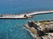
Spinalonga
The Venetian fortress: construction and strategic role
Spinalonga, guarding the natural harbour approaches off Elounda in the Mirabello Gulf, was developed into a major Venetian sea fortress in the late 16th century AD. It belongs to Venice’s wider fortification policy for protecting sea routes and controlling key coastal gateways under pressure from piracy and Ottoman expansion.
Chronologically, the fortifications are linked to surveys and planning in the 1570s AD, with the engineer Genese Bressani commonly cited in connection with the design. The year AD 1579 is repeatedly recorded as a foundation milestone under Luca Michiel, memorialised by inscriptions within the fortress fabric.
A critical strengthening phase is recorded in AD 1584, when defence was reinforced higher on the terrain to counter vulnerabilities from nearby hills. The fortress is described as heavily armed for its time, with a recorded complement of 35 cannons, underlining its role as a premier sea fort.
After most of Crete fell to the Ottomans in the Cretan War (AD 1645–1669), Spinalonga—together with Souda and Gramvousa—remained a Venetian outpost for decades, functioning as a “last hold” and strategic base.
The final transfer occurred in AD 1715: after a prolonged siege, the fortress was surrendered to the Ottomans (the surrender is specifically dated to 4 October AD 1715), after which the islet developed a stronger residential/community character under new conditions.
The leper colony (AD 1904–1957): documented timeline
Spinalonga became internationally known for its function as a leper colony in the early 20th century. The decision framework for compulsory isolation is recorded in AD 1903, and the first major arrivals are recorded in October AD 1904, with an initial intake reported as 251 patients.
In its early decades the settlement operated primarily as isolation rather than treatment: infrastructure was limited, stigma severe, and movement strictly regulated. Daily life depended on mainland supply and water logistics, while social exclusion often extended beyond the island through silence and administrative marginalisation.
From the mid-1920s AD onward, improvements are recorded, including the arrival of medical provision (a physician is cited in AD 1925) and the gradual establishment of basic care structures. By the late 1920s, adapted buildings are described as serving as a functional medical unit, signalling a shift towards organised health support.
The 1930s AD mark a major internal transformation: in AD 1936 the arrival of Epaminondas Remoundakis is linked to the formation of a residents’ organisation (often referred to as a “Brotherhood”), which pushed for hygiene, infrastructure, and collective standards of life on the island.
A documented milestone appears in AD 1938, when permission is recorded for works that improved accessibility around the island (including a perimeter path suitable for residents with disability). During this broader period, upgrades such as electric power and even a cinema are reported, illustrating the development of a functioning—if exceptional—settlement.
Medical developments after the Second World War changed the trajectory: new treatments are recorded from AD 1948, and isolation rules progressively weakened. Formal abolition of isolation is recorded in AD 1955, while the final transfer of patients to a specialised unit in Attica took place in AD 1957, marking the colony’s closure.
Spinalonga did not become immediately empty: the last resident priest is reported as remaining until AD 1962 for ecclesiastical commemoration duties. Later, the site entered protected heritage management (a key institutional milestone is recorded in AD 1976), followed by restoration and organised visitation.
Sightseeing
- Spinalonga (Venetian fortress): Walk a complete late-16th-century sea fort in its true strategic setting, guarding the approaches off Elounda in Mirabello Bay.
- Spinalonga (leper colony, AD 1904–1957): A powerful place of modern social history; the remains of streets, houses and public buildings make the story tangible, and the visit works best when treated as a memorial as much as a landmark.
- Ancient Lato (above Kritsa): One of the most legible examples of a Cretan city-state; the site explains, in a single landscape, how inland power linked to a coastal harbour.
- Panagia Kera (Kritsa): A small church with major Byzantine frescoes (13th–14th centuries AD), among the most important painted interiors on Crete.
- Olous (Elounda): The experience of a partly submerged ancient town in shallow water close to shore adds a rare archaeological dimension to the coastline.
Flavours
- Lassithi olive oil: The defining local staple, reflecting the region’s long agricultural continuity in the Neapoli–Kritsa hinterland.
- Village cheeses and rusks: Everyday products of the upland pastoral economy, ideal with simple meze and local spirits.
- Honey and mountain herbs: Aromatic produce from the interior that pairs naturally with the salt-edge character of Mirabello’s coast.