

Vatika bay and Neapoli, from E
Vatika bay and Neapoli
Vatika Bay, nestled along the eastern coast of the Mani peninsula, is a region of contrasting landscapes: from rugged cliffs to serene sandy beaches, and from fertile plains to olive-studded hills. Its natural harbour, though modest, has long made it a focal point for settlements and maritime activity.
Ancient Period
Archaeological evidence indicates human presence in Vatika since the Bronze Age (c. 3000–1100 BC). The area was part of Laconia, influenced by Mycenaean civilization. Finds in the surrounding hills suggest small settlements engaged in farming, animal husbandry, and trade. Pottery fragments and stone tools reveal a community integrated into broader Aegean networks.
Classical and Hellenistic Periods (5th–1st century BC)
During classical times, the region was sparsely populated, with small agricultural villages. Its coastal location allowed limited engagement with sea trade. In Hellenistic periods, Vatika’s hinterland served as pasture and farmland for the growing populations of nearby coastal towns. Its strategic yet remote position meant it was often left to local autonomy rather than centralized authority.
Roman Era (1st century BC – 4th century AD)
Under Roman rule, the bay region retained a quiet rural character. Roads connecting Vatika with Gytheio and other Laconian centers facilitated the transport of olive oil, wine, and other agricultural products. While no major Roman urban centers existed here, villa estates and modest farmsteads illustrate a degree of prosperity and integration into the imperial economy.
Byzantine Period (4th–15th century AD)
The Byzantine era left its mark in ecclesiastical architecture, with small chapels dotting the hillsides and a fortified settlement near the bay. Maritime activity was limited, though local fishermen exploited the abundant resources of the bay. The region, like the rest of Mani, was intermittently raided by pirates, influencing the development of isolated hilltop villages for safety.
19th Century and Greek Independence
During the Greek War of Independence (1821–1830), the Maniots played a crucial role, and Vatika Bay provided a staging area for supplies and small naval operations. Post-independence, the area gradually stabilized, with Neapoli emerging as a local administrative center and commercial hub.
The 20th century brought modern roads, electricity, and expanded agriculture. Neapoli became a center for olive oil production, while Vatika Bay gained a reputation for its quiet beaches and traditional Maniot villages. Today, the bay and town are peaceful destinations, retaining the authenticity of a region that has weathered millennia of change.
Why Visit
Beaches and Coastal Beauty: Vatika Bay offers calm, sandy stretches and clear waters ideal for swimming and snorkeling.
Neapoli Village: Stroll through its narrow streets lined with traditional stone houses, discover local cafes, and visit the main church, which has Byzantine-era origins.
Nearby Sightseeing: The The magnificent castle-city of MOnemvasiá. A short drive leads to the ancient Laconian sites and the stunning cliffs of the eastern Mani coast.
Culinary Experiences: Sample specialties of Mani in Neapoli, including fresh seafood, local cheeses, and dishes flavored with regional herbs and olive oil.
Sarakiniko forevah!
N. Elafonisos
Elafonisos is a small island—covering about 19 km²—lying just off the coast of the region of Vatika Bay in southern Laconia, Peloponnese, Greece. In antiquity it was not a true island, but a peninsula called Onou Gnathos (“Donkey’s Jawbone”), as described by the geographer Pausanias. It later separated from the mainland because of rising sea levels and tectonic activity.
The region of Vatika Bay itself has been inhabited since the Early Helladic period (c. 3000–1900 BC) and hosts one of the oldest submerged towns in the world, Pavlopetri, in the bay’s waters. On the mainland side, the ancient city of Voies (modern Neapoli) flourished under Laconian (Spartan) influence.
Classical to Byzantine Era
During the classical era, Voies formed part of the Spartan state, while the peninsula of Onou Gnathos (later Elafonisos) remained on the fringes. Over the centuries, the coastline changed: as the sea transgressed, the land bridge between the island‑peninsula and the mainland was gradually submerged. Geological studies show that around Late Bronze Age the sea level in Vatika Bay was about 4.5 m below present mean sea level, and by classical times further changes had occurred.
Under Byzantine rule, the area continued to be a quiet backwater with occasional pirate raids, given its southern location opening to the Aegean and the route toward Kythera. The landscape—plain, mountains, sea, bay—remained much as it is today, and the small fishing and farming communities persisted.
Modern History
In the modern era, the settlement on Elafonisos grew especially in the 19th century. During the Greek War of Independence (1821 AD onwards) the bay of Vatika and the waters around Elafonisos served as a naval base for the Greek fleet. The island became part of the modern Greek state under a treaty with Britain in 1850 AD. Today Elafonisos is a municipality and a popular summer destination, while the mainland plain of Vatika remains largely agricultural—olive groves, onions, fishing in the bay.
Why Visit
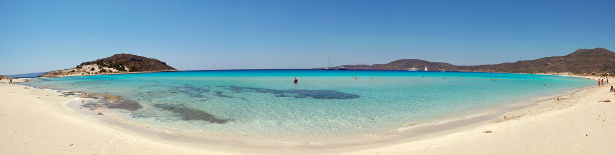
- Natural beauty and beaches: Although the island is small, its beaches (notably the famous Simos Beach) offer fine sand, turquoise waters and dunes.
- Historical resonance: Sunken cities await for you to put your mask on!
- Outdoor activities: On land you can hike up to Vigla or Vardia on the island and enjoy panoramic views of the bay, the plain of Vatika and the sea
- Nearby mainland villages & landscape: After visiting the island, explore the plain of Vatika, the coast, the small villages, and the sense of space created by mountains, bay and sea.

