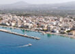
Stretching along the northern coast of the Peloponnese, Xylokastro gazes across the blue waters of the Corinthian Gulf, backed by pine forests that sweep down from the slopes of Mount Trikala. Today it is a lively seaside town known for its beaches and the famous Pefkias pine forest, yet its story reaches deep into the history of Corinthia—an area continuously inhabited and contested since antiquity.
Ancient Period – Between Pellene and Sikyon
In antiquity, the region that now includes Xylokastro lay between the powerful city-states of Pellene, Aegira, and Sikyon, forming part of the greater territory of ancient Corinthia and Achaea. Archaeological finds in the nearby area of Sythas, Rethi, and Evrostina indicate the presence of Mycenaean and Classical-era settlements, small coastal communities linked to maritime trade and agriculture.
This was a coastline of scattered villages rather than a single urban center—an area serving as a crossroads for travelers moving between Corinth and Patras, and a natural stop for fishermen and merchants navigating the eastern Corinthian Gulf.
The nearby ancient Pellene, located inland, was a member of the Achaean League and played an important role in regional politics. Xylokastro’s coast may have served as Pellene’s port area or anchorage, as the land gently descends to a sheltered shore suitable for small ships. The fertile plain and mild climate made it ideal for vines, olives, and grain cultivation, sustaining the local population for millennia.
Roman and Early Christian Eras – A Land of Estates and Villas
Under Roman rule (2nd century BC onward), the region experienced a period of relative prosperity. Roman colonists and wealthy locals established villa estates along the fertile coast, combining agricultural production with seaside leisure. The discovery of ancient walls, pottery fragments, and coins around the modern town testify to continuous habitation.
During the Early Christian and Byzantine eras, small basilicas appeared along the Corinthian shoreline, reflecting the spread of Christianity through rural communities. The old coastal road, which roughly corresponds to today’s route, linked these settlements to Corinth, which became the seat of an important metropolitan bishopric.
Byzantine and Medieval Period – The Frontier of Empires
In the Byzantine period, the area that would later become Xylokastro was part of the theme (province) of the Peloponnese, centered around Corinth. The population retreated slightly inland during times of raids, especially during the Slavic incursions (7th–9th centuries), when many coastal settlements were abandoned or fortified.
The mountain villages of Trikala, Evrostina, and Stymfalia flourished during this era, serving as refuges for the inhabitants and forming a defensive network overlooking the gulf.
With the Frankish conquest (13th century), after the fall of Constantinople in 1204, the region passed into the hands of the Principality of Achaea. Medieval documents mention coastal “castles” or watchtowers guarding the shoreline—rudimentary fortifications built of wood and stone to protect from pirates and to signal inland villages in case of attack.
It is precisely from such a “wooden fort”, (xylino kastro) in Greek, that the modern town would later take its evocative name: Xylokastro.
Ottoman and Venetian Period – Life Between Empires
During the Ottoman period (15th–19th centuries), the area remained a coastal agricultural zone, with small settlements attached to the inland communities of Trikala and Evrostina. The population cultivated raisins, olive oil, and cereals, exporting them via small harbors along the Corinthian shore.
For a time in the late 17th century, under the Venetian occupation (1687–1715), the region experienced a brief revival in trade and fortification building, but the Ottoman return restored the area to its quiet, rural rhythm.
Local tradition maintains that the name “Xylokastro” began to appear more widely in the 18th century, referring to a wooden defensive structure near the shore—possibly a Venetian watchtower that had decayed into a timber frame. Around it, fishermen and farmers began to settle permanently, forming the nucleus of a new coastal community.
Modern Period – From Independence to a Seaside Resort
The modern town began to develop significantly in the late 19th and early 20th centuries, particularly after the construction of the Athens–Patras railway line, which made Xylokastro easily accessible. It soon gained popularity as a summer retreat, attracting visitors seeking the unique combination of seafront and pine forest landscape.
The name “Xylokastro” most likely derives from a wooden fortification or watchtower that once stood in the area during medieval times. Although no clear remains survive, the name evokes the image of a coastal outpost, essential for monitoring maritime activity along the Corinthian Gulf.
Sights
Pefkias Forest
A defining feature of Xylokastro, this coastal pine forest stretches along the shoreline and has been appreciated since the early 20th century. It offers a rare combination of shade, sea breeze, and natural beauty.
Panagia Korfiotissa Monastery
Set on elevated ground, the monastery provides sweeping views over the gulf. It is a place of tranquillity, highlighting the harmonious meeting of mountain and sea.
Trikala Korinthias
Located inland, this mountain village is known for its traditional architecture and scenic setting. It makes for an excellent excursion, offering cool retreats in summer and snowy landscapes in winter.
Flavours
Corinthian Currants
The region is famous for its production of currants, once a cornerstone of Greece’s export economy. Their rich flavour reflects a long agricultural heritage.
Fresh Fish from the Corinthian Gulf
Local tavernas serve freshly caught seafood, simply prepared to highlight the clarity and freshness of the ingredients.
Local Wine and Tsipouro
The Corinthian hinterland produces notable wines and spirits, perfectly complementing local dishes and expressing the rural character of the land.