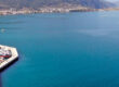
Larymna, view of the harbour
Larymna, lying on the northern edge of the Evvoikos Gulf, stands at the meeting point of ancient Boeotia and Locris—two regions often intertwined yet historically distinct. Today a quiet coastal settlement adjoining the modern industrial port of LARCO, Larymna hides a far older identity: a fortified harbour of the Classical world, a Roman naval base of considerable importance, and a medieval refuge that witnessed the shifting powers of Crusaders, Byzantines, and Ottomans. Its history is less visible in comparison with more dramatic archaeological sites—but make no mistake: Larymna’s role as a maritime gateway has been consistent for over two millennia.
From Prehistory to the Archaic Age
The broader region around Larymna shows signs of habitation from the Bronze Age, although direct prehistoric remains in the immediate settlement are sparse. The coastline, fertile pockets of land, and its sheltered gulf provided natural advantages for early travellers moving between Euboea, Boeotia, and the Malian Gulf.
By the Geometric and Archaic periods (900–600 BC), Larymna emerges more clearly in the record as a coastal outpost tied culturally and politically to Boeotia. Its position made it a maritime interface for ancient Orchomenos and later Thebes, offering them a seaward connection even though both cities were inland. This early role as a harbour of larger powers would continue through antiquity.
Classical and Hellenistic Larymna: A Port of Two Worlds
A unique feature of Larymna is that ancient authors describe two settlements, Upper Larymna (Ano Larymna) and Lower Larymna (Kato Larymna).
Upper Larymna (Ano Larymna)
Situated inland, near today’s village of Prophitis Ilias, Upper Larymna was originally a Lokrian (Opuntian) settlement. This inland town held the identity and traditions of the Eastern Lokrians, who were known for their ties to Thebes and their participation in the Persian and Peloponnesian Wars.
Lower Larymna (Kato Larymna)
The coastal town grew as a fortified harbour under Boeotian influence. During the Classical period, it served as the seaward access point of Thebes, especially during the period of Theban military ascendancy in the 4th century BC (notably under Epaminondas). The prosperity of Boeotia and the military campaigns of Thebes required a port capable of receiving supplies, ships, and troops.
In the Hellenistic period, shifting alliances and the rise of Macedonian power altered the balance. After the Roman conquest of Greece (2nd century BC), the Opuntian Lokrians regained control, and both Larymnas gradually fused into a dual-character community, oscillating between Boeotian and Lokrian identity depending on broader political circumstances.
Archaeological remains—mostly submerged or fragmentary—suggest significant harbour installations, warehouses, walls, and civic structures that once lined the ancient shoreline.
Roman Naval Base: A Strategic Rebirth
he Roman era brought Larymna’s most historically documented phase. Recognising its natural harbour and centrality in Aegean shipping routes, the Romans transformed Lower Larymna into a naval and commercial station.
Part of the “Port System” of Roman Central Greece
he port linked the Roman road networks of Boeotia with the maritime routes toward Euboea, Thessaly, and the Aegean islands. It served as:
- a supply station for the Roman fleet in the Eastern Mediterranean,
- a safe anchorage during military operations,
- and a logistical centre facilitating movement between northern and southern Greece.
Roman Engineering and Expansion
Several underwater structures visible today—particularly foundations, pier remnants, and retaining walls—likely date to this period. The harbour was deep and protected, ideal for the needs of Roman triremes and merchant ships.
Larymna prospered during the 1st–3rd centuries AD, blending Roman administrative organisation with local Greek culture. The two Larymnas were administratively united during this time, forming a strong coastal–inland pair connected by a short road.
Late Antiquity and Early Christianity
With the decline of the empire, the port retained importance for a time, serving regional trade routes along the Euboean Gulf. Early Christian activity is evidenced by scattered finds, including fragments of basilicas and burial remains, though the exact location of the main ecclesiastical complex is uncertain.
Earthquakes, silting, and the disruption of shipping in the 6th–7th centuries AD contributed to a slow decline. By this period, much of ancient Lower Larymna had begun succumbing to natural subsidence—one reason why large sections of antiquity today lie beneath the waterline.
Byzantine, Frankish, and Ottoman Periods: A Faded but Strategic Position
In Byzantine times, the region did not host major urban centres but continued to appear in administrative documents—largely because any harbour between Thebes and Eastern Locris was strategically valuable.
After the Fourth Crusade (1204 AD), Larymna and its hinterland passed intermittently between:
- Byzantine Greek lords,
- the Duchy of Athens under the Franks,
- and later Catalan and Florentine forces.
Though not a major fortress, the site allowed control of coastal movements. During the Ottoman period (15th–19th centuries), Larymna became a small fishing and farming settlement with modest local activity. The harbour was occasionally used by local trade vessels travelling between Chalkida, Atalanti, and the villages of Boeotia.
Modern Era: The Rise of Industry
The modern identity of Larymna is strongly connected to the exploitation of nickel and laterite ore in the mid-20th century. The establishment of the LARCO metallurgical plant and port transformed the once-historic harbour into one of the major industrial shipping points of Greece.
Although this industrial presence visually dominates today’s coastline, the ancient remains—both on land and submerged—form a quiet reminder of the port’s older, even more strategic centuries.
Sightseeing
Though not a major tourist centre, the area offers something authentic and historically interesting, the submerged ruins of Ancient Larymna
Remains of ancient quays, foundations, and harbour installations are visible beneath the clear waters along the shoreline. Best seen on calm days; ideal for photography or snorkeling for those familiar with shallow-water exploration.
What Can Be Seen Underwater Today
The underwater remains extend parallel to the shore and include:
- Foundations of Ancient Buildings
- Harbour Walls and Quay Lines
- At least one harbour basin or internal docking area is identifiable
- Piers / Mole Remains
- Road and Pavement Sections
- Pottery and Minor Finds
Visibility and Access
The main viewing zone is around 150–250 m east of the small marina, along the curved shoreline toward the industrial pier. This is where most of the submerged walls and foundations lie.
Without diving
On calm days with clear water, you can see:
- rows of submerged stones,
- building outlines,
- and the edges of quays from the shore or from a small boat.
Snorkeling
The depth (often 1–3 m) makes the site easy to observe with a mask, provided you stay in safe, shallow areas near the beach.
The clarity of the Evvoikos Gulf often makes details surprisingly visible.
Diving
There is no organised diving centre in Larymna specifically for the site, and diving on archaeological locations in Greece is regulated. However, the shallow nature of the ruins makes them accessible for surface-level observation without violating restrictions.